Projects
Lost Cities - Cutucu Project
Location
Cordillera de Cutucu, Morona Santiago
Stage
Exploration/Advanced Exploration
Commodities
Gold, Silver, Copper, Zinc, Lead
Since 2017, the Company’s application of modern exploration techniques in southeastern Ecuador’s Cutucu region—guided by over a decade of archival research led by CEO, Dr. Keith Barron, into the fabled gold mines of the Cutucu Cordillera’s “Lost Cities”—has led to the identification of multiple highly prospective gold and copper targets.
These include several blind epithermal gold systems, such as Crunchy Hill and Kuri‑Yawi, comparable to those that led to the discovery of the world‑class Fruta del Norte deposit (now in production by Lundin Gold) in the adjacent Cordillera del Condor.
Beneath Aurania’s epithermal targets, newly reprocessed MobileMT geophysical data have revealed potentially significant porphyry copper systems, while sediment‑hosted copper mineralization akin to the Central African Copper Belt has been identified at the 14‑kilometre‑long Tsenken prospect.
In response to an evolving political environment and increasingly challenging business conditions for exploration companies in Ecuador, Aurania has elected to adopt a prudent “wait‑and‑see” approach while discussions continue with the government and potential partners. The Company remains confident in its strategic direction, with a continued focus on advancing gold and strategic metals projects in Europe, while selectively evaluating additional opportunities in other jurisdictions.
What Is epithermal gold?
“Epithermal” gold deposits refer to a type of gold deposit that formed close to the surface at the time that the deposit formed. Epithermal deposits in southeastern Ecuador, of which Lundin Gold’s Fruta del Norte deposit is an excellent example, formed approximately 150 million years ago. We expect epithermal deposits in Aurania’s Lost Cities – Cutucu Project to have been formed around the same time as Fruta del Norte.
When the Company acquired its initial 42 mineral concessions in the Cutucu region from Dr. Keith Barron in 2017, little was known of the geologic potential of the area since the centuries-old activities of the Conquistadors. The Shuar people, who historically inhabited the Cutucu region, did not traditionally engage in gold mining before the arrival of the Spanish.
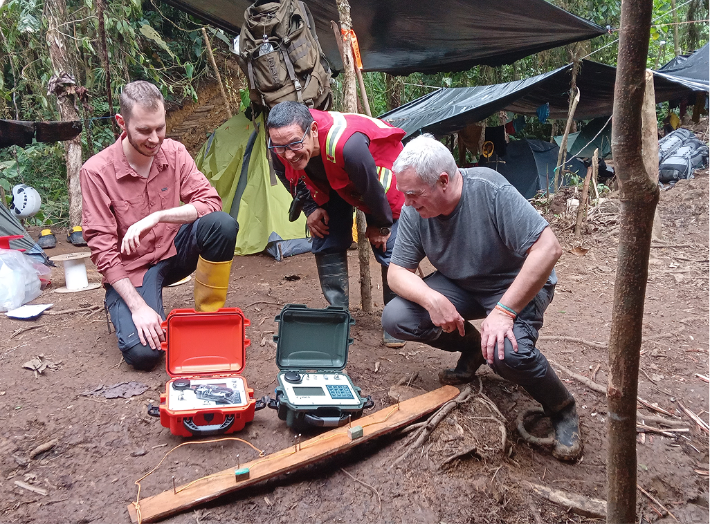
Aurania initiated modern exploration in the area, including an airborne Mobile MagnetoTellurics (MobileMT) geophysical survey in 2021. The data from that survey was reprocessed using new techniques in 2024 and 2025, revealing highly prospective new anomalies at the Awacha target (see press release dated June 27, 2025).
While the state of knowledge of these areas was very preliminary in nature in 2021, now, with the benefit of hindsight from the new data acquired utilizing new technologies, age-dating, geological mapping and sampling over the last four years, a much more coherent picture has emerged. In addition, much information has been released in the public filings of Lundin Gold and Solaris from the adjacent and contiguous Cordillera del Condor, immediately south of Aurania’s block of concessions, providing further geological context for Aurania’s target areas.
Geological Context of the Cutucu Project
The Cordillera de Cutucu and the Cordillera del Condor are part of a Jurassic back-arc rift system which extends roughly north-south through the whole of Ecuador. In the two Cordilleras, the fault system which demarcated the Jurassic rift basins was later reactivated and reversed in the Tertiary, forming the height-of-land characteristic of the Cordilleras.
The mineralizing systems were then unroofed by erosion and exposed. In the case of the Condor, the erosion and uplift have removed several kilometres of sedimentary cover, exposing many copper porphyry systems and generating large areas of placer gold mineralization where epithermal vein systems have been entirely eroded away.
In the Cutucu, the sedimentary cover over the mineralizing systems remains largely intact, so that the very tops of epithermal systems comprising hotspring sinters and siliceous terraces are preserved; the main body of the epithermal systems, as well as likely porphyry systems, remain preserved at depth. Additionally, the Cutucu shows abundant evidence that the fault basins contained playa lakes that evaporated to dryness, depositing thick layers of salt and gypsum.
Conditions became favourable for the mobilization of copper and silver in saline fluids from volcanic rocks into shales and sandstones. This combination of unique geological conditions deposited and preserved extensive sheets of copper-silver mineralization in sediments, akin to Kamoa-Kakula, Dzezkazgan, and the Kupferschiefer. To date, this type of sediment-hosted style copper mineralization remains untested by drilling.
Blind Deposit Exploration
In the Cutucu, the porphyry and epithermal systems outcrop rather poorly or not at all. Their presence is not obvious but is revealed by geophysics and geochemistry. The world-class Fruta del Norte (FDN) gold-silver deposit, approximately 100 km to the south in the more deeply eroded Condor, was fortuitously preserved in a down-dropped graben block and covered by a Cretaceous sandstone which protected it from erosion. This was a “blind discovery” since there was very little gold on the surface. Its discovery by Aurania’s predecessor company Aurelian Resources, founded by Dr. Barron, came through the application of geochemical sampling for pathfinder-type elements, i.e., other metals which occur in gold systems but are much more abundant and more easily detected than gold itself.
Early application of this methodology in the Cutucu led Aurania to the discovery of Crunchy Hill, Kuri-Yawi and other epithermal prospects. Actively artisanal-mined gold alluvials at Patuca, just outside the Aurania concession block, were determined to be derived from eroded early Cretaceous paleoplacers; in other words, the placer gold accumulations were more or less coincident in time with the epithermal vein system formation some 230 million years ago. This suggests that at least some of the sinter systems spread out over 30 kilometres within the Aurania claims could host another bonanza-grade type FDN.
Prospective Graben Settings
Intensive geological mapping has shown there are at least two, and possibly three, down-dropped grabens arrayed north-south through the Project. These became apparent after very careful reconnaissance mapping and reinterpretation of the biostratigraphy of the fossil endowment.
Grabens form through extensional forces in the earth that pull apart the rocks horizontally. The central block will fall vertically into the space created and a deep canyon may result. The extensional spreading allows intrusion of porphyry-producing magmas, producing hot hydrothermal fluids that can pond in the dilatant zones: grabens are recognized as one of the most productive mineralizing environments.
Aurania Among First Industry Users of MobileMT
At the time of the initial MobileMt survey, Electromagnetic (EM) data inversion was performed using a one-dimensional (1D) algorithm. In recent years, EM inversion technology has significantly improved, particularly for areas with rugged terrain. As a result, Aurania recommissioned Expert Geophysics Surveys Inc. to reprocess the 2021 MobileMT data using the latest 2D inversion technology. The 2.5D inversion code that was applied is more objective and comprehensive than the previous 1D technology, as it considers the actual topography of the area being investigated, yielding robust lateral and vertical resolution, resulting in more accurate mapping of the subsurface conductivity, which may be related to mineralization.
Aurania was one of the very first companies worldwide to adopt MobileMT, but there were few publicly-available examples to demonstrate the expected geophysical signature of porphyry deposits using the MobileMT method. For a “real world” test and ground truthing, Aurania had the contractors fly over the known Panantza and San Carlos porphyry copper bodies outside of our concessions. These were proven deposits with extensive drilling. The MobileMT results generated outstanding signatures, with close spatial correlation of the ore bodies with strongly anomalously geophysical signatures. Based on this test study we flew large portions of our project using the MobileMT method, yielding several anomalies. The mineralized area of the Panantza/San Carlos test grid had only minor topographic relief, however, unlike our area in the much more rugged Cutucu. The primitive 1-D data inversion available at the time was unable to correct for the more rugged terrain, and we later drilled some targets that subsequently proved to be spurious. We have great confidence in the improved 2.5-D reprocessing of our data to produce reliable results: the new processing method accounts for the more significant terrain correction, and the new anomalies agree well with known geology, other geophysics and the porphyry copper exploration model.
The Lost Cities Cutucu Project
Aurania’s Lost Cities Cutucu Project was an outgrowth of historical research in the Archive of the Indies, Seville, and the Vatican Library, which suggested that the rich gold mines of Logroño de Los Caballeros and Sevilla del Oro, active circa 1565-1605 were in the Cutucu Cordillera.
The Company used an extremely innovative approach with Metron Inc. of Reston, Virginia, a company that uses Bayesian Theory in geo-location of lost objects, including downed aircraft. Metron successfully located Logroño, which is a large alluvial plain along the Rio Santiago, just off our concession block. This was confirmed by the recovery of large amounts of alluvial gold by our geologists.
We believe that this gold deposit was in part fed from our property. Attempts to partner with the construction company owning the gold alluvial area have to date been unsuccessful. Sevilla del Oro remains “lost” but it is believed to be in the drainage basin of the Pastaza River and outside our concessions.
Aurania can find no evidence of past mining activity on the copper-silver, and lead-zinc-silver showings on our concessions. Dr. Barron’s experience in Guatemala, Mexico and Colombia suggests that the Colonial Spanish would have sunk shafts and adits on any of these areas had they been known at that time. We believe that these are virgin areas.
The road network detected on the concessions by LiDAR surveying is almost certainly pre-Colombian and could be many thousands of years old and related to the lost culture in the Upano Valley, north of Macas. It appears that the pre-Shuar inhabitants mined and transported salt along these roads.
Awacha, Sunka, Kirus, Awacha Norte:
These prospect areas were initially revealed from a 400 metre-spaced airborne magnetometer and radiometric survey carried out in 2017. To date, Awacha has been the focus of our exploration efforts, but all prospects remain undrilled.
Awacha and Awacha North appear to be in an area of uplift where early Jurassic rock is at surface. These prospects do not outcrop well, being covered by a thin stratum of mudstone, which in the ravines is eroded away sufficiently to expose porphyry intrusives. In addition, stream sediment sampling produced wide anomalous areas of several kilometres extent where copper and molybdenum were elevated.
At both Awacha and Awacha North, zones of classic-type QSP (quartz-sericite-pyrite) alteration and “D-type” mineralized veinlets with molybdenite and chalcopyrite are present. D-type veins are very distinctive with a medial septum of sulphide, only seen in magmatic systems like porphyries.
Awacha has been mapped in detail using the Anaconda mapping method. The recasting of the MobileMT survey has shown possible presence of six discrete porphyry bodies (see press release dated June 27, 2025). Awacha North has been cursorily mapped but not explored with MobileMT.
We believe that Awacha and Awacha Norte represent multiple potential Cu-Mo porphyry bodies in a cluster, much like Solaris’ Warintza area, located south of Aurania’s concessions. Sunka and Kirus areas have yielded porphyry-style mineralization but have not been mapped in detail.
Crunchy Hill, Kuri-Yawi, Apai, Kuripan:
This collection of targets has high potential for epithermal-type gold-silver veining. These targets were discovered fortuitously very early in Aurania’s exploration efforts in the area, near the paved road where excellent access facilitated sampling. Apart from Crunchy Hill, all contain siliceous hotspring sinter on the surface, with evidence of reeds and other plants entombed in the splash zone of geysers.
Very distinctive “geyserite” has also been found. This is a rock of solidified tiny spheres of quartz that represent sand grains on which silica nucleated as they were tumbled in the convecting hotspring. Hotspring-type rocks are located immediately above the ore zone at FDN, and Aurania staff were considerably encouraged by their discovery.
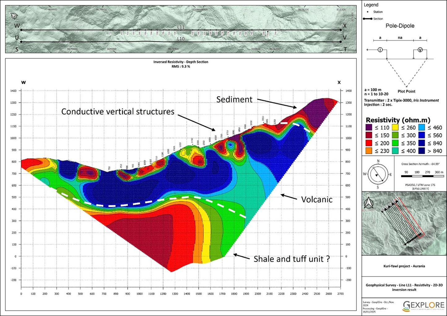
Epithermal banded veins have been encountered by drilling, but fluid inclusion paleothermometry indicated that trapping temperatures were low, though salinities high. This means we were drilling on the periphery of the systems or not deep enough where the mineralizing fluids had already deposited their metals and were cooling. Only determined and persevering exploration with the drill will guarantee discovery. The results of an Induced Polarization (IP) Survey were ambivalent.
Recasting of the MobileMT over Kuri-Yawi, however, strongly suggests two areas of potential sulphide flooding related to epithermal processes, as well as a deeper zone that bears the signature of a buried porphyry body.
The Crunchy Hill area has not been covered by MobileMT. Crunchy Hill is a zone of disseminated sulphide with minor epithermal veining, which is enriched in the pathfinder elements Ag, As, Mn, Sb, Se, Tl, and Hg. Further geophysical surveys and a drilling campaign are required.
Tsenken:
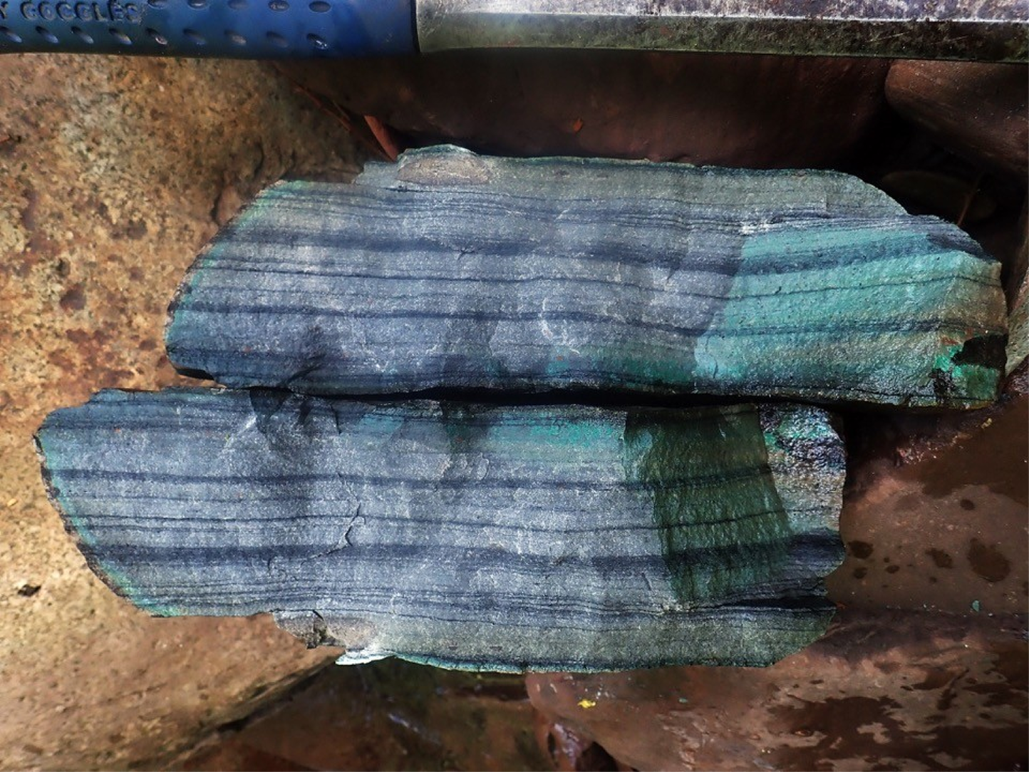
Tsenken was a wholly unexpected target area. Early in the exploration, the field assistants returned from the field with specimens over half a metre in size and more than 50 kg weight of significant amounts of chalcocite (a copper-rich (80% Cu) sulphide mineral) in bedded shales and sandstones. This sediment-hosted style of high-grade copper-silver mineralization, common to the large and high-grade copper deposits of Central Africa and the Kupferschiefer, was previously unrecognized in Ecuador and represent a compelling new exploration target.
Informed by our early version of the MobileMT over this area we drilled several targets that unfortunately turned out to be duds. The problem was a misinterpretation of the sedimentary stratigraphy in this area, which was only sorted out by Professor Gregor Borg and Consultant Cristian Vallejo after a number of holes had been drilled.
These sorts of copper deposits occur in areas of maximum fluid flow where there are favourable and reactive host rocks. By initiating a serious study of analogues from Ivanhoe Mines’ Kamoa-Kakula Deposit in the Central African Copper Belt, we were very excited to discover a large arcuate zone of high conductivity that parallels the surface trace of a major fault and subcropping Santiago Formation for 14 kilometres.
The Santiago is a pyritic carbonaceous mudstone unit which could be an analogue to the chemically reactive pyritic diamictite that hosts most of the copper at Kamoa-Kakula. The coincidence of a strongly copper-mineralized rock indicating the presence of an effective mineralizing system, subsurface conductivity anomaly associated with a known fault/plumbing system and receptive host stratigraphy makes Tsenken highly prospective. This target remains undrilled.
Tiria-Shimpia:
The Tiria-Shimpia zone appears to be localized along the east side of a graben fault and is hosted by limestone. The mineralization consists of semi-massive and vein-hosted Zn-Pb-Ag-Ba-bearing minerals and could represent the distal expression of the Tsenken copper-silver system.
Extending for over nine kilometres and only partly covered by the MobileMT survey, it has been explored with four drill holes, all of which encountered mineralization.
Tatasham:
The Tatasham target corresponds to a magnetic low lying within a major magnetic high anomaly. This magnetic low is interpreted as a classic de-magnetization of the rock by hydrothermal alteration related to the core of a porphyry system.
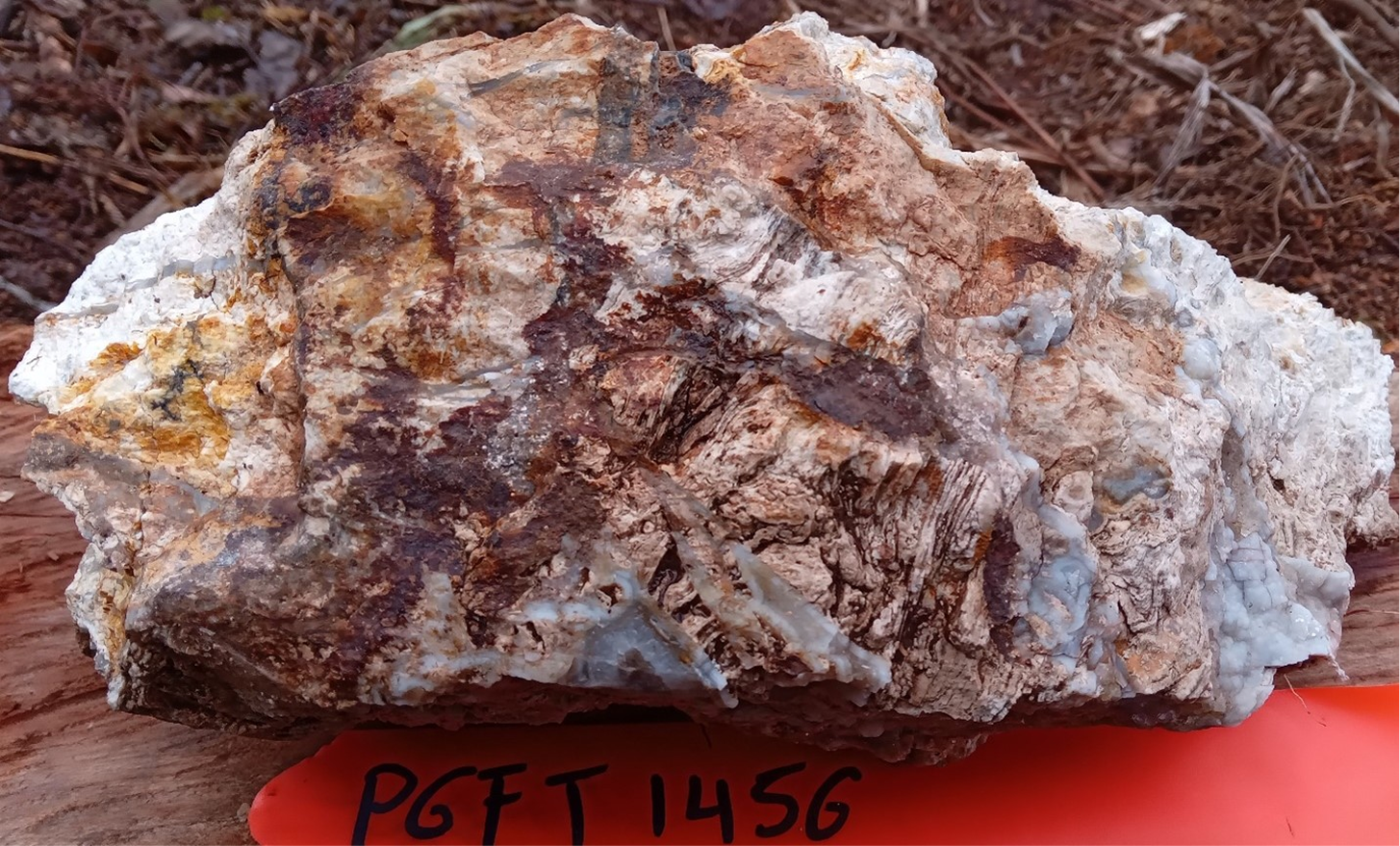
The Anaconda mapping conducted in the area confirmed the presence of an intensive hydrothermal alteration, which justified a scout drilling campaign in 2023. The third drill hole intersected a thick silicified zone interpreted as the distal portion of an epithermal system at the same stratigraphic level as the sinter horizon.
This indicates that we are in the upper level of the epithermal-porphyry system with the Tatasham prospect representing an epithermal target likely overlying a porphyry system at depth. Follow-up field verification confirmed the presence of sinters and extensive hydrothermal breccias.
The thickness of the near-surface silicified system is comparable to that of Fruta del Norte and is situated within a small graben of similar age. Additional surface exploration is warranted to delineate the sinter zone and define targets for the next phase of drilling.