Projects
Brittany project
Location
Brittany, France
Stage
Exploration
Commodities
Gold, Antimony, Tin, Tungsten, Molybdenum, Copper
In December 2025, Aurania was granted three exploration permits (PER) for polymetallic metals and gold in the Brittany Peninsula of western France. These permit areas Epona, Taranis and Bélénos, are covering areas of 51 km², 359.5 km² and 440.9 km² respectively. This marks a new opportunity for Aurania in a jurisdiction where institutional stability and high-quality infrastructure make exploration safe and more efficient than other areas in the world.
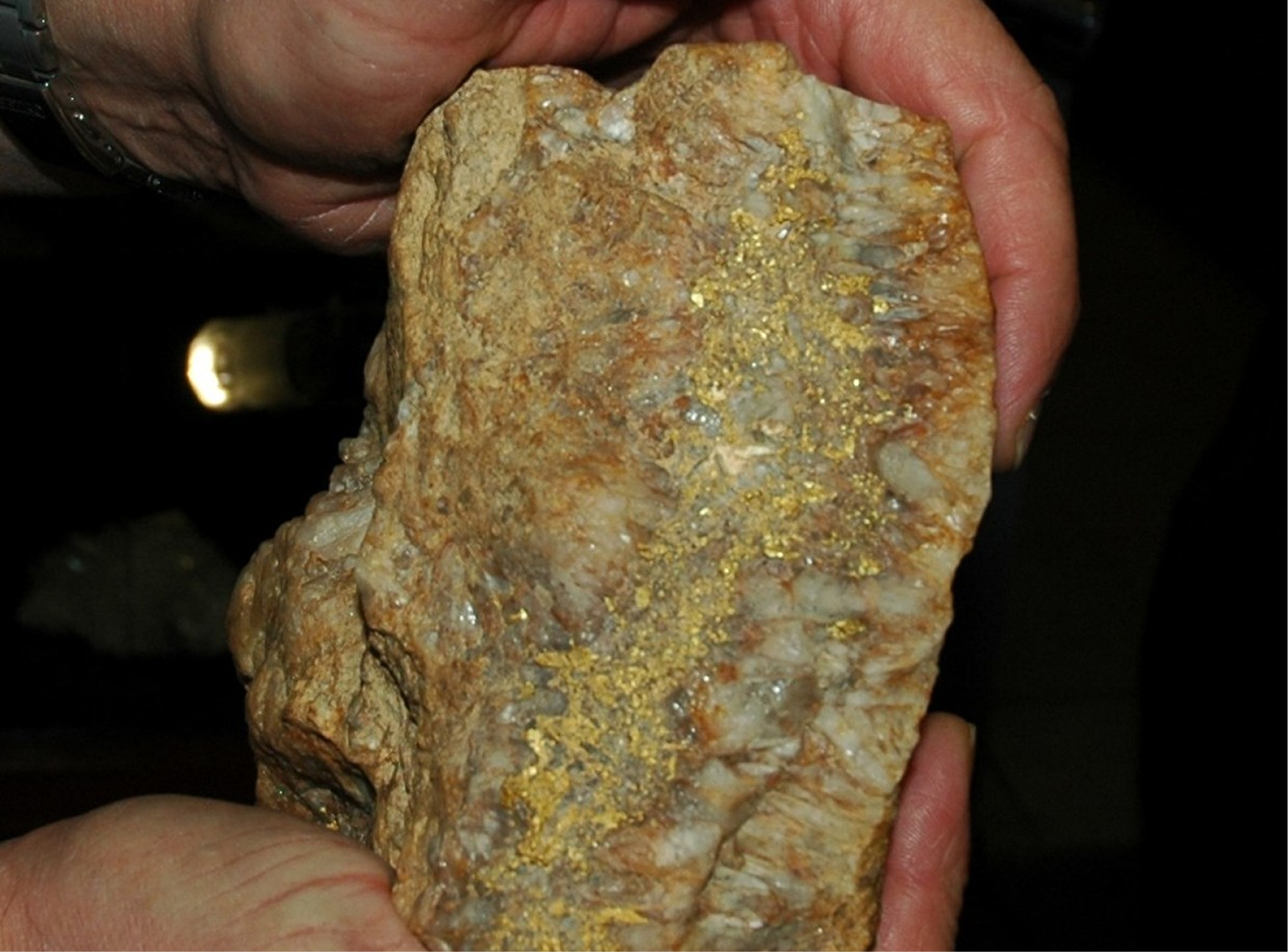
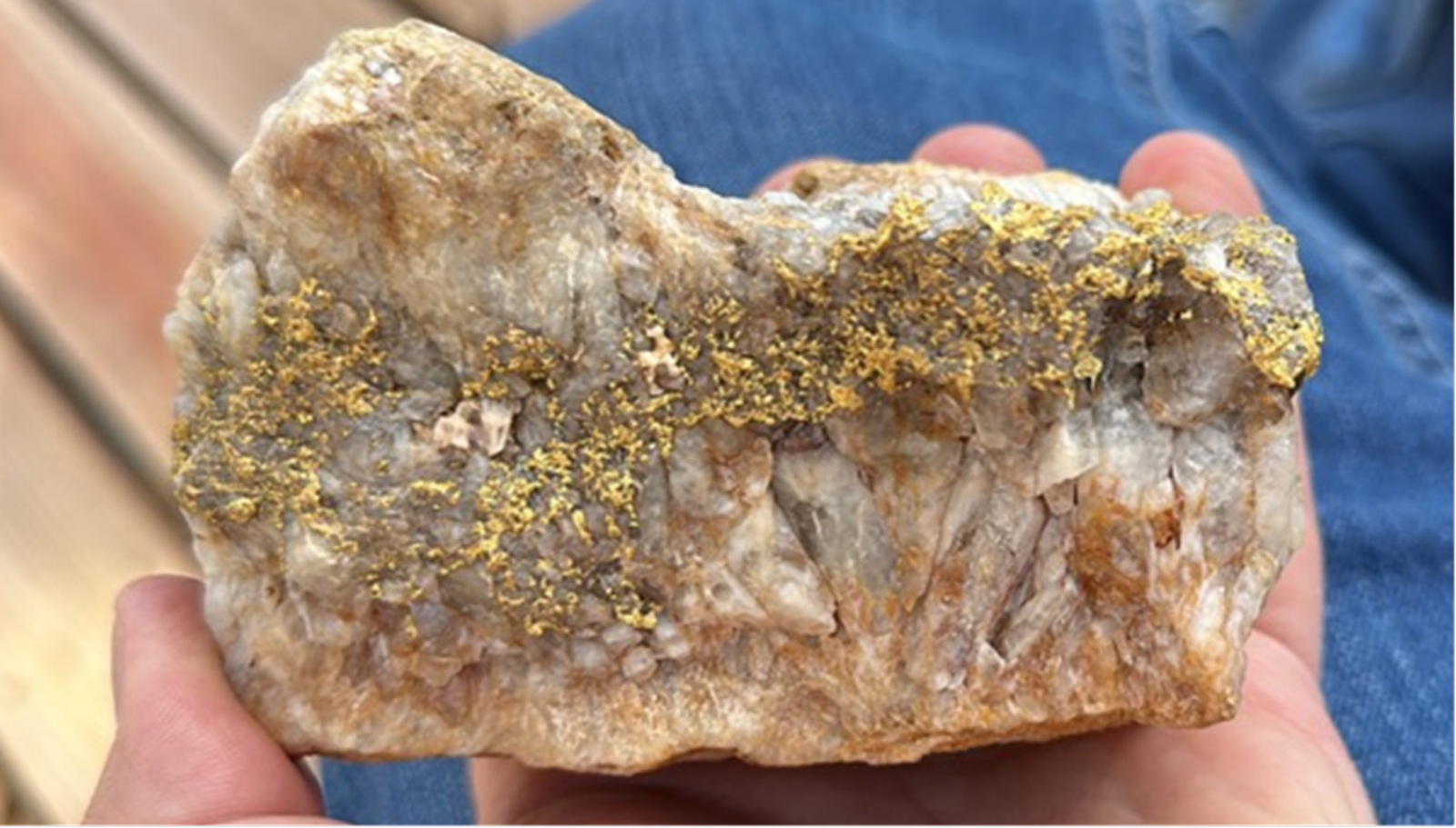
The French government’s decision to grant Aurania these permits is an excellent opportunity for Brittany and the Pays de la Loire to gain a deeper understanding of their subsurface resources and for France to find new sources of metals to secure the country’s supplies through exploration to be conducted by Company. It also marks a new opportunity for Aurania in a jurisdiction where institutional stability and high-quality infrastructure make exploration safe and more efficient than other areas in the world. The initial mining inventory studies conducted by the French Geological Survey (BRGM) confirmed the presence of gold associated with strategic metals over more than 150 km along the shear zone, and in some cases at exceptional grades. This demonstrates the strength of the hydrothermal activity that occurred in the region.
Aurania announced the filing of an exploration permit named Epona back in 2023 (see press release dated July 24, 2023). Subsequently, in October 2023, the Company submitted two additional applications, Taranis and Bélénos, covering areas of 359.5 km² and 440.9 km² respectively. These areas are located in southern Brittany and northern Pays de la Loire in France.
Europe under pressure over its metal supplies
As the battle for critical metals increases, Europe finds itself vulnerable – consuming 20% of global metals but producing only 3%.
A clean energy future depends on secure access to metals.
European Critical Raw Materials Act: by 2030, 10% of the EU’s annual needs for extraction.
Full project details
Since Antiquity, France has been a major mining country throughout its history, with mineral resources playing a key role in its economic and scientific development. However, from the early 1980s, with the end of exploration on its territory, the mining industry began a decline, eventually disappearing almost completely by the end of the 20th century. This disinterest was primarily due to political and macroeconomic reasons, as from a purely geological perspective, France and specially the Brittany Peninsula, still hosts significant potential for a wide range of mineral resources, notably strategic metals (nickel, antimony, tin, tungsten, etc.), base metals (lead, zinc, copper), as well as precious metals (silver, gold, and platinum-group elements). Recently, the European Union launched the European Critical Raw Materials Act, a plan which aims to secure Europe’s supply, particularly by promoting exploration.
More than 40 years have passed since the last exploration campaigns, and during this period exploration techniques have evolved dramatically, driven by advances in computing, geophysical and geochemical methods, satellite imagery, GPS technology, and a much-improved understanding of deposit formation. Thanks to these new, high-performance tools, mainland France has effectively become a “greenfield” territory again, with strong discovery potential.
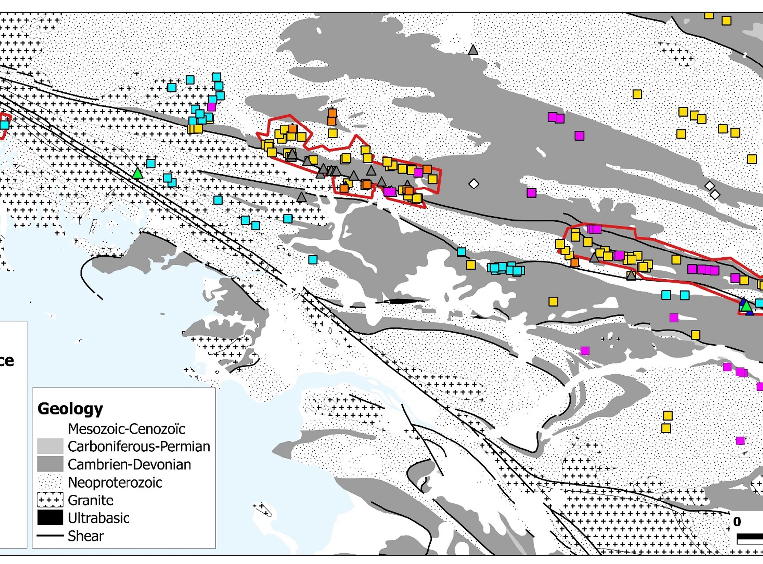
The region comprises ancient geological formations known as the Armorican Massif, part of the Hercynian orogeny, renowned for hosting significant deposits worldwide, such as those in western Spain, the Bohemian Massif in the Czech Republic, and Newfoundland in Canada. Aurania has chosen to focus on the South Armorican Shear Zone, a major structural accident where orogenic gold mineralization is concentrated with strategic metals along more than 150 km. This mineralization reflects significant Late Hercynian hydrothermal activity, which is favorable for the presence of precious metals, base metals, and strategic metals such as antimony, tin, tungsten, molybdenum, and copper.
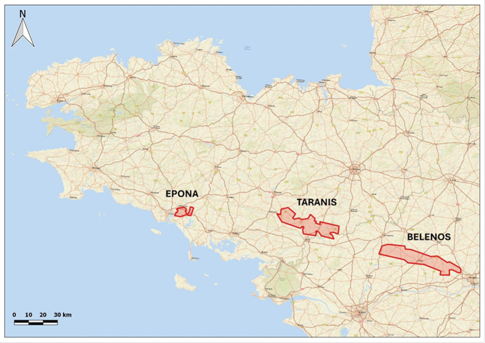
Epona
The Epona permit is located approximately 2 km south of the South Armorican Shear Zone, on Hercynian-aged granitic terrains containing gold-bearing quartz veins. In the surrounding rivers, the presence of gold, tungsten, and tin has been reported by the French Geological Survey (BRGM). The area is affected by argillitic alteration, indicative of hydrothermal activity.
Gold in the area was first discovered in 1875 when municipal workers founded two quartz boulders extremely rich in gold approximately 400 m apart. One of these blocks, containing 922 grams of gold, is currently exhibited at the National Museum of Natural History in Paris. In 1903, Abbé H. Breuil, a renowned prehistorian, confirmed this discovery in the journal “L’Anthropologie,” adding that a third, “more substantial” nugget had reportedly been found.
Taranis
The geology of the area consists of Precambrian to Silurian sedimentary rocks intruded by the Lanvaux orthogranite in its southern part. The Taranis permit is located in the supracrustal domain of the Hercynian belt along the South Armorican Shear Zone, a major fault that acted as a conduit for hydrothermal fluids.
Around this major tectonic fault, numerous polymetallic mineral occurrences (zinc, lead, copper, silver, and antimony) are distributed, almost always associated with gold, according to studies by the French Geological Survey (BRGM). These mineral occurrences were exploited during the Roman times and more recently in the early 20th century. Depending on the area, grades reported by the BRGM range from a few grams up to 113 g/t Au, and reach up to 150 g/t Ag, 1.64% Cu, 6.27% Pb, and 5.9% Zn.
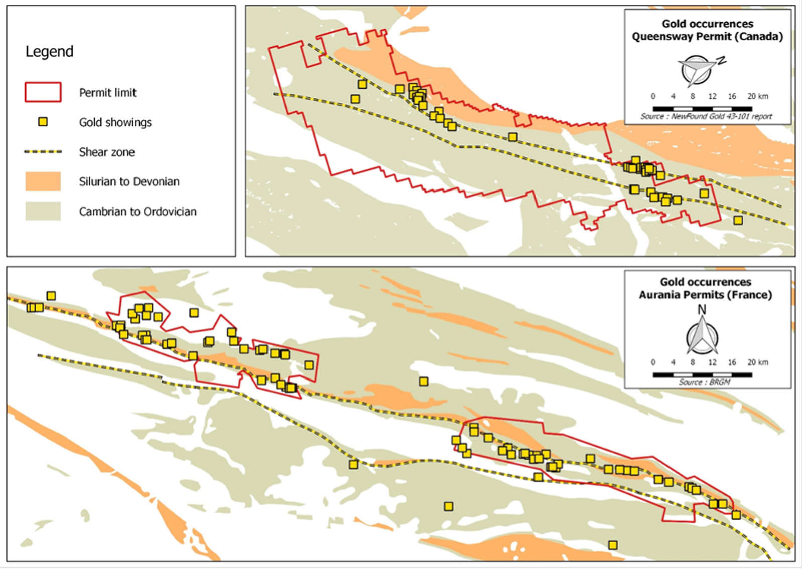
Comparing the abundance and dispersion of gold occurrences as well as the favourable tectonic and geological context, the permit area shows similarities with the Queensway project of NewFound Gold in Newfoundland.
Belenos
The geology of the area consists of Precambrian to Devonian sedimentary rocks intruded by granites in its eastern part. To the north lies a Devonian pull-apart basin bounded by a complex system of dextral shear faults forming two distinct fault corridors within the permit area. These major tectonic structures acted as conduits for the circulation of hydrothermal fluids.
Along the main shear zone, numerous sulfide mineralization of antimony, copper, and base metals have been discovered, accompanied by gold, which is also frequently free, very pure, and can reach 200 microns in size. Grades vary from a few grams per ton to 37.5 g/t Au. This mineralization is accompanied by hydrothermal alteration with sericite-chlorite and tourmaline.
In the southeastern part of the permit, copper, molybdenum, and tin mineralization occurs within quartz veins hosted in aplite dykes or directly cutting the host granite. This mineralization could belong to a copper porphyry system.