Twenty Mile Project
Overview
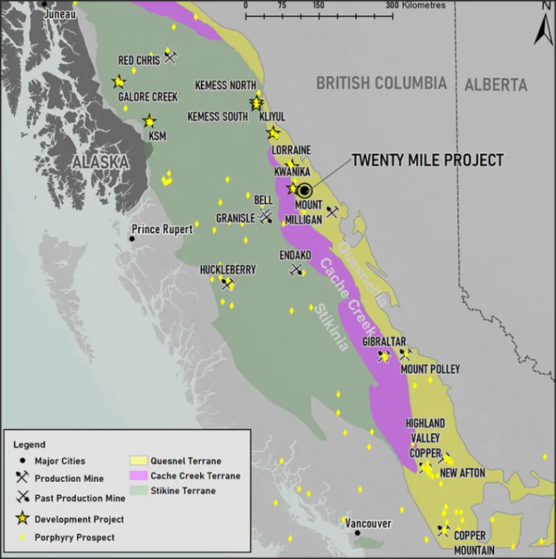
The Twenty Mile (TM) Project is located in BC’s Prolific Quesnel Trough Porphyry Belt, host to world class porphyry deposits such as Highland Valley Copper (Teck), Copper Mountain (Hudbay), Mt Polley (Imperial Metals), New Afton (New Gold), and Mount Milligan (Centerra).
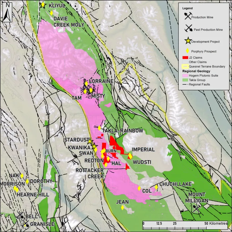
The area around TM is surrounded by advanced development projects such as Northwest Copper’s Kwanika/Stardust and Lorraine projects, Pacific Ridge’s Kliyul Project as well as a host of Alkalic Cu-Au targets.
Location
British Columbia, Canada
Stage
Early
Size
12,315 Ha
J2 Interest
100%
Deposit types
Porphyry Cu / Epithermal Au

Location
Located approximately 220km from Prince George and 80km Northwest of Mount Milligan, Twenty Mile can be accessed by vehicle through a network of well-maintained gravel logging roads.
The TM Project consists of 3 distinct claim blocks consisting in size of 1828Ha (TM), 953Ha (Imperial) and 9533Ha (Burn) . The overall property is accessed by a network of logging roads which have recently expanded due to increased forestry in the region. There are active logging roads that reaches the Burn Block as well as an ATV trail that transects its northern extent., The TM northern extent can be accessed via ATV from the Germansen road, but the majority of the block must be accessed via foot or Helicopter.

Geology & Mineralization
The Quesnel terrane is a Mesozoic arc complex that stretches the length of the province and contains numerous late Triassic to Early Jurassic calc-alkaline and alkaline intrusions hosting Cu-Au-Mo-Ag porphyry deposits. The region around TM is characterized by Takla Group Volcanics overlain by the Chuchi lake and Twin Creek successions. These are intruded by various phases of the Hogem Batholith. The terrane is bound by the Pinchi Fault to the West and the Manson-McLeod fault to the east with many cross structures marking a complex structural environment for porphyry emplacement.
The entire region is masked by glacial overburden which has complicated exploration campaigns of the past. This is more apparent in many of the lower elevation areas of the region in which TM is largely located.
Exploration History
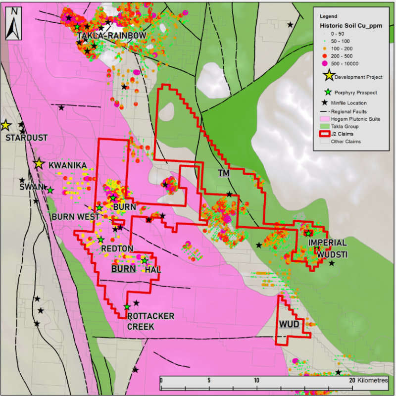
Exploration in the area east of Kwanika has consisted mostly of traditional soil geochemistry and some geophysics. Past soil grids covered various areas of the TM claims and were conducted by The Luc Syndicate (1971) Imperial Metals (1986), Westin Resources (1986, 1991,1992), Placer Dome (1990) and Kiska Metals (2011-12). A large area of copper and gold anomalous soil results occur near the Wudsti and Imperial Minfile showings on and near the TM and Imperial claim blocks. This area has also had past production of coarse grain placer gold in nearby creeks.
The Burn showing was drilled by Placer Development in 1972, 1976 and 1979 for its molybdenum content and no significant copper grades were encountered. This despite copper in soil anomalies up to 4000ppm or 0.4% Cu above the drilling area and noted chalcopyrite in outcrop maps to the west.
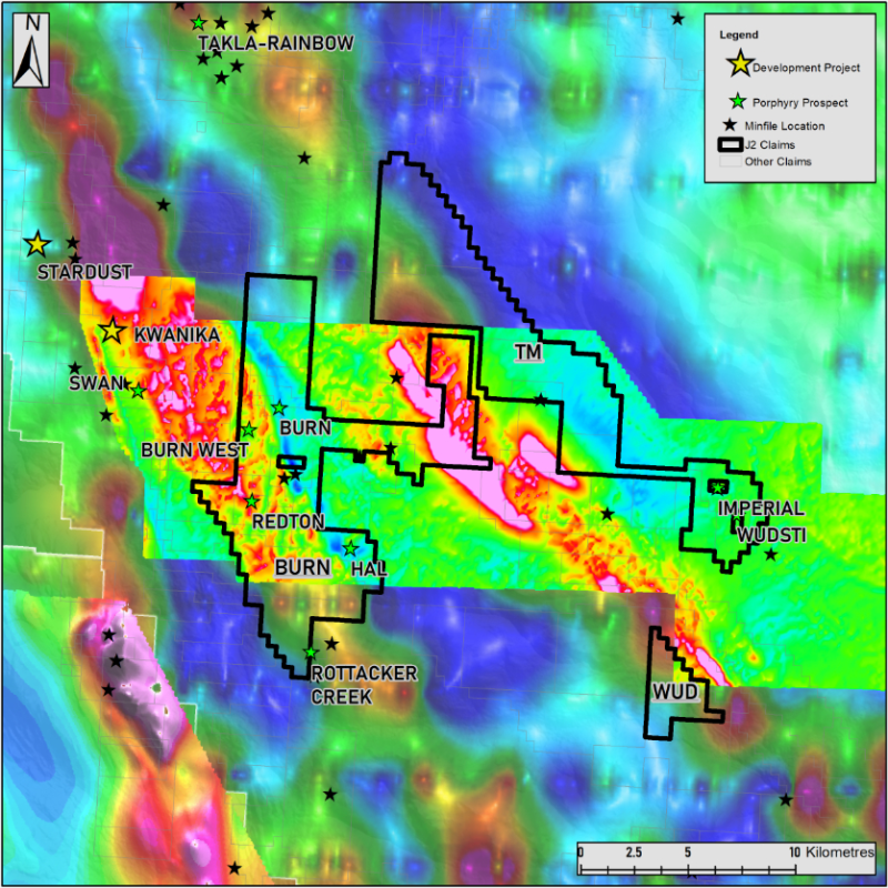
A 2010 aerial magnetic survey was conducted in 2010 by Kiska/Pacific Ridge over the Redton property, a portion of which covers the Burn block. A large magnetic-radiometric survey was also conducted by Natural Resources Canada in 2005 that covered most of the region and included a large portion of the TM claim blocks. In 2024, neighboring Pacific Ridge announced an exploration target directly east of Kwanika at their Redton Property. This IP Chargeability high is believed to follow northeast trending cross structures which follow directly to the Kwanika south zone deposit. The Burn West anomaly is located geologically along strike from this target along a similar cross structure.


Future Plans
J2 conducted a large-scale reconnaissance MMI Sampling program over the property in 2022 and 2024. Anomalous copper in soil was encountered in the southern Burn block and the northern extent of the TM block. A multi-year area based permit was obtained in 2023 on the Burn block with hopes to conduct IP geophysics in the near future as well as further infill soil geochemistry sampling.
